Respond to climate change, inspect the forest
from
a bird's eye view
Drones in the service of forestry
Respond to climate change, inspect the forest from a bird's eye view
Drones in the service of forestry
Examine the condition of the forest ecosystem.
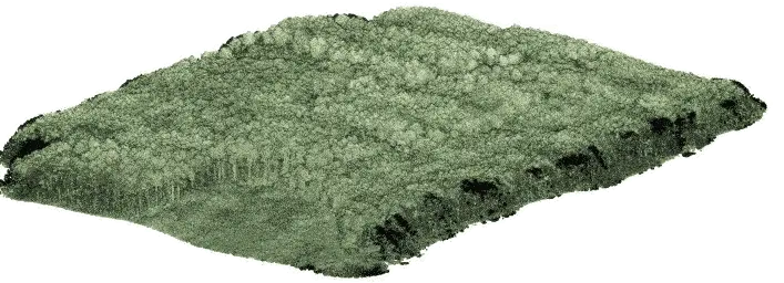
See how your crops develop. Precisely locate pests. Carry out your inventory without time-consuming detours. You don't have to check every piece of the forest yourself - a drone with a specialized camera will do it quickly and accurately. It will rise hundreds of metres above the ground and inventory multi-hectare areas in no time. Use the report on the state of your forest ecosystem and win the unequal climate battle. Precisely.
See how to use drones in forestry.

Examine the condition of the forest ecosystem.
See how your crops develop. Locate pests precisely. Carry out your inventory without time-consuming detours. You don't have to check every piece of the forest yourself - a drone with a specialized camera will do it quickly and accurately. It will rise hundreds of meters above the ground and quickly inventory multi-hectare areas. Use the report on the state of your forest ecosystem and win the unequal climate fight. Precisely.
See how to use drones in forestry.
Everything modern forestry needs
Key solutions designed to monitor, measure, and manage forest ecosystems.
FOREST HEALTH ANALYSIS
Detect forest health risks early using AI-powered aerial analytics.
FOREST INVENTORY
Access accurate, up-to-date forest inventory data derived from aerial surveys.
DAMAGE ASSESSMENT
Quickly assess the extent and impact of natural disturbances.
AFFORESTATION MONITORING
Track forest regeneration and evaluate planting success with high efficiency.
FOREST METRICS ANALYSIS
Extract measurable forest parameters directly from aerial data.
ILLEGAL ACTIVITY DETECTION
Monitor forests regularly and detect unauthorized activities early.


DETECT PESTS
Precisely locate regions
infested with pests.

PRECISE CALCULATIONS
Check exactly how many trees there are in your area.

CHECK THE CONDITION OF THE TREE CROWN
Detect trees that have been
infected or are not developing correctly.

LOCATE MISTLETOE
Check which trees are infected with mistletoe.
Forest stand health analysis

DETECT PESTS
Precisely locate regions
infested with pests.

PRECISE CALCULATIONS
Check exactly how many trees there are in your area.

CHECK THE CONDITION OF THE TREE CROWN
Detect trees that have been
infected or are not developing correctly.

LOCATE MISTLETOE
Check which trees are infected with mistletoe.
Analysis of the forests health
Tree inspection with pinpoint accuracy

REPORT FROM HARD
TO REACH AREAS
Check even the hardest-to-reach spots.
A 5 meter long runway is enough to take-off.

ESTIMATION OF THE DIAMETER
OF THE TREE CROWN
Study the condition of the tree crowns,
their diameter and correctness of their growth.

FOREST AREA
INVENTORY
Perform inspection of large
forest areas with high efficiency.

Tree inspection with watchmaking precision

ESTIMATION OF THE DIAMETER
OF THE TREE CROWN
Study the condition of the tree crowns,
their diameter and correctness of their growth.
REPORT FROM HARD
TO REACH AREAS
Check even the hardest to reach places.
A 5 meter long runway is enough to take off.
FOREST AREA INVENTORY
Perform inspection of large forest areas with high efficiency.
Forest metrics analysis
Estimate tree height, crown diameter and canopy condition. These metrics support forest inventory and mensuration workflows without extensive fieldwork. Consistent measurements improve planning accuracy and reporting. Obtain fast access to reliable quantitative forest data.
CANOPY COVER
How much of the ground is covered by tree canopy when viewed from above?
CANOPY HEIGHT MODEL
How the canopy height varies spatially?
FOLIAGE HEIGHT DIVERSITY
How plant material is distributed across the vertical layers of the canopy?
Forest metrics analysis
Estimate tree height, crown diameter and canopy condition. These metrics support forest inventory and mensuration workflows without extensive fieldwork. Consistent measurements improve planning accuracy and reporting. Obtain fast access to reliable quantitative forest data.
CANOPY COVER
How much of the ground is covered by tree canopy when viewed from above?
FOLIAGE HEIGHT DIVERSITY
How plant material is distributed across the vertical layers of the canopy?

CANOPY HEIGHT MODELS
How the canopy height varies spatially?
Results to date
We have been cooperating with the Regional Directorate of State Forests in Zielona Góra for over 6 years. Our data provides real support for decisions concerning forest protection and management.
1.5 mln
hectares covered in orthophotomaps
600k
diseased and dead trees detected
Results to date
We have been cooperating with the Regional Directorate of State Forests in Zielona Góra for over 6 years. Our data provides real support for decisions concerning forest protection and management.
1.5 mln
hectares covered in orthophotomaps
600k
diseased and dead trees detected


