With the rapid development of technology, precise acquisition of large spatial datasets has been revolutionised by laser scanning systems such as LiDAR. These systems are developing fast thanks to their exceptional accuracy, and they are especially popular in sectors such as civil engineering, construction, forestry and technical inspections, where precision and speed are crucial.
What is LiDAR and how does it work?
LiDAR (Light Detection and Ranging) is an active terrain scanning technology that uses laser pulses to precisely measure the distance between the sensor and the Earth's surface or other objects. LiDAR works similarly to radar, but instead of radio waves it uses laser light, which makes the data extremely accurate and detailed.
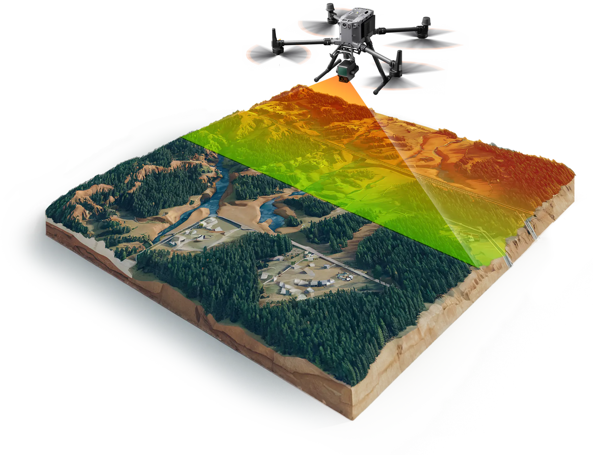
A LiDAR system emits a laser beam towards the ground, and dedicated sensors analyse the time it takes for the pulse to return after reflecting off an object. This makes it possible to calculate the distance to the reflection point precisely. At the same time, the laser optics determine exactly the direction in which the beam was sent. Combining these systems produces a detailed “point cloud” – a three-dimensional representation of the surveyed area.
Key components of every LiDAR system
- Laser: A laser light source that generates precise, short pulses, allowing distance to be measured accurately. Laser scanners most often use lasers in the infrared band.
- Scanner optics: A device that dynamically steers the laser beam while precisely monitoring the direction of each emitted beam. The optics ensure full coverage of the surveyed area and effective acquisition of spatial data.
- GNSS receiver (Global Navigation Satellite System): Precise GNSS RTK receivers provide the drone's exact position in space, which is essential for georeferencing and aligning the data collected in the field.
- IMU (Inertial Measurement Unit): A navigation system that records the spatial orientation of the sensor using a set of accelerometers and gyroscopes (tilt, rotation, acceleration), stabilising LiDAR data and improving the accuracy of its positioning.
All these components work in sync to create precise spatial terrain models in the form of a cloud of measurement points with defined XYZ coordinates, ideal for further spatial and design analysis.
Applications of LiDAR in drones
Combined with drones, LiDAR technology is used in many sectors thanks to its versatility, precision and speed. The most important applications include:
3D maps and terrain modelling
LiDAR delivers very detailed terrain models in the form of 3D point clouds and precise elevation maps. LiDAR drones can scan large areas quickly and accurately, including hard-to-reach ones. These models are used, among others, in urban planning, road design, analysis of areas at risk of landslides or floods, and planning of large infrastructure investments.

Surveying and cartography
In surveying, LiDAR provides very accurate elevation data, which is the basis for precise maps. It enables fast, detailed field measurements that traditionally required many days of work by survey teams. The result is data used to produce cadastral maps, maps for design purposes and as-built maps.
Construction and engineering
LiDAR strongly supports the construction and engineering sector, enabling fast inspections of building sites and accurate analysis of surface topography. Precise LiDAR data allow more accurate infrastructure design, optimised earthworks, calculation of cut and fill volumes and effective monitoring of construction progress. LiDAR is also excellent for monitoring the stability of structures such as bridges and flood embankments.
Forestry
In forestry, LiDAR plays a key role, enabling detailed measurement of stand density, assessment of tree health and detection of areas damaged by disease, insects or extreme weather. Because it can penetrate dense vegetation, a LiDAR drone can map forest structure in detail, helping foresters manage resources and plan protection and management activities more effectively.
See drone applications in forestry.
Technical inspections – bridges, power lines, pipelines
LiDAR works particularly well for inspecting technical infrastructure. LiDAR drones allow safe and fast scanning of power lines, bridges and pipelines, identifying potential problems such as structural damage, incorrectly positioned components or trees growing dangerously close. Regular LiDAR inspections increase safety and lower infrastructure maintenance costs.
How to choose a LiDAR system for a drone?
Choosing the right LiDAR system for a drone should be preceded by a careful analysis of several key technical parameters. This way we can be sure that the sensor will meet our expectations and produce data suited to the specific project.
Key technical parameters of LiDAR systems
- Scanning range: defines the maximum distance at which the sensor can collect data accurately. A longer range makes scanning large areas more efficient by allowing flights at higher altitudes.
- Measurement accuracy: a key parameter that affects the quality of the data collected. Professional LiDAR systems achieve accuracy from a few to a dozen or so centimetres, which is essential in surveying and engineering projects.
- Pulse rate (scanning frequency): affects the density of points collected during scanning. A higher rate gives more detailed spatial models and a better chance of penetrating vegetation, which matters especially in highly detailed spatial analyses.
- Number of returns (echoes): the sensor's ability to record multiple returns from a single laser pulse (e.g. first and last return). More returns are very important, especially in forestry, allowing better penetration of dense vegetation and more detailed mapping of terrain structure.
- Field of view (FOV): the sensor's viewing angle, which determines the area it can cover in a single pass. A wider field of view directly shortens the time needed to scan large areas.
Weight and drone compatibility
A LiDAR sensor must also be chosen with its weight and compatibility with the carrying drone in mind. Every drone has a maximum payload, and exceeding it can seriously affect safety, flight stability and flight time. Heavier professional sensors require larger, more advanced unmanned platforms such as the DJI Matrice 350 RTK.
A very convenient solution that increases compatibility and simplifies mounting is the use of Skyport-type ports, which allow quick mounting and seamless integration of the sensor with the drone. The Skyport, used among others in professional DJI drones, provides not only easy mounting but also automatic communication between the drone and the sensor, which makes configuration and field operation easier.
Another important aspect of compatibility is power supply. The market offers sensors powered directly by the drone as well as sensors with their own built-in power source (e.g. dedicated batteries). Self-powered sensors are more universal, as they can easily be integrated with different drone platforms regardless of the voltage or power they can supply. This increases operational flexibility and allows LiDAR sensors to be used with more drone models.
When choosing a LiDAR sensor, you should therefore carefully consider its weight, mounting type (e.g. Skyport) and power supply – depending on the available drone platforms and the nature of your projects.
Integration with RTK and GNSS
A very important requirement for a LiDAR system is integration with GNSS (Global Navigation Satellite System) technology. An additional requirement is RTK (Real-Time Kinematic) technology. This significantly improves the accuracy of spatial data and its georeferencing, delivering measurement data accurate to within a few centimetres.
Examples of drones that support LiDAR
Choosing the right drone is crucial to using LiDAR sensors effectively. Not every drone is suitable for integration with these sensors – what matters is a high payload, mounting compatibility, flight stability and integration with advanced positioning systems. Below are examples of models that work very well with LiDAR sensors:
DJI Matrice 350 RTK
The DJI Matrice 350 RTK is a professional drone platform with a high payload and high flight precision. RTK technology provides accurate positioning, which greatly increases the precision of data collected with LiDAR sensors. The Matrice 350 RTK supports the Skyport standard, so integration with sensors such as the DJI Zenmuse L2 is particularly quick and easy.
CHC X500
The CHC X500 is a professional industrial drone that performs very well in applications requiring a high payload and stable flight. Its design allows convenient and secure mounting of even heavier LiDAR sensors. The CHC X500 is especially recommended for surveying and engineering applications, where high accuracy and reliability in various terrain and weather conditions matter.
BX8 (BZB UAS)
The UAV BX8 is a professional multirotor drone built for tasks requiring a high payload and flight stability. It is ideal for integration with LiDAR sensors, also in difficult terrain. Its open architecture and configurable setup make the BX8 a versatile platform for surveying, engineering and environmental applications.
EkoSky VTOL (BZB UAS)
EkoSky by BZB UAS is a VTOL (Vertical Take-off and Landing) drone that combines the advantages of multirotors and fixed-wing unmanned aircraft. Vertical take-off and landing let it operate even in difficult terrain, while horizontal flight provides a very long flight time and a large operating range. EkoSky can carry various types of LiDAR sensors, making it an excellent solution for large terrain mapping, forestry, precision agriculture and environmental analysis projects.
Types of LiDAR sensors used in drones
There are many different types of LiDAR sensors on the market, differing in technical parameters, purpose, price and applications. The choice of LiDAR sensor should be based on the individual requirements of the project, the expected data quality and the budget for the device.
Low-cost and mid-range systems
Sensors in this group are designed for users who need solid data at a reasonable price. They are most often chosen for standard applications in surveying, construction and general terrain analysis. The most popular models are:
- DJI Zenmuse L2: a compact LiDAR sensor with a measuring range of about 190 metres. It is exceptionally easy to mount and integrate with popular DJI Matrice drones. Thanks to its affordable price and high data quality, it is a popular choice among survey companies for standard elevation maps, terrain inspections and general terrain modelling.
- CHC AlphaAir AA10: an advanced mid-range sensor offering higher accuracy and a longer scanning range. It delivers more detailed and accurate point clouds, making it well suited to more demanding applications such as detailed surveying analyses, power line inventories and detailed infrastructure modelling. The scanner's architecture allows seamless integration with DJI Matrice series drones as well as custom drones.
- Rock Robotics R3 Pro: A sensor offering good data quality at moderate cost. Its range and data accuracy allow comprehensive technical inspections, 3D infrastructure modelling and advanced spatial analysis in engineering and construction projects.
Professional LiDAR systems
Sensors in this class are designed for professional users who expect the highest precision and level of detail. They are successfully used in projects requiring exceptional accuracy and in complex terrain and infrastructure analyses. The most popular professional sensors are:
- RIEGL miniVUX: A top-class LiDAR sensor with exceptional measurement precision, high point cloud density and very good range. It penetrates vegetation extremely well, which is why it is often chosen for forestry projects, detailed infrastructure inventories and comprehensive surveying analyses. In addition, the wavelength it uses makes the scanner excellent for measuring ice and snow
- YellowScan Navigator: An advanced professional LiDAR sensor with excellent precision and effective penetration of dense vegetation. Its bathymetric capability also allows it to scan shallow water bodies, riverbeds and coastal zones. It is ideal for demanding forestry, environmental and hydrological projects. Its compact design makes integration with popular professional drones easy, e.g. the DJI Matrice 350 RTK
LiDAR map of Poland – available resources
The LiDAR map of Poland is a spatial data resource acquired by the Head Office of Geodesy and Cartography (GUGiK) and made publicly available through the Geoportal.gov.pl service. This data is a rich source of spatial information used by many specialists in various fields.
Where to find free LiDAR data?
The largest and most accessible source of free LiDAR data is the Geoportal service run by the Head Office of Geodesy and Cartography. It gives users public access to LiDAR data covering the entire territory of Poland. The data is free of charge and can be used in surveying, construction, forestry and environmental projects. Geoportal provides access both to raw point clouds and to processed elevation models.
How to turn on LiDAR in Geoportal?
To display LiDAR data on the Geoportal website, follow these steps (the service is in Polish):
- Go to www.geoportal.gov.pl.
- On the main map, click the icon on the left „Zawartość mapy” (Map contents).
- Select the category „Dane do pobrania” (Data to download) or „Dane wysokościowe” (Elevation data).
- Select the relevant LiDAR data layers, such as „Numeryczny Model Terenu (NMT)” (Digital Terrain Model) or „Chmury punktów LiDAR” (LiDAR point clouds).
- The data will be overlaid on the base map, allowing visual analysis and assessment of the available data.
How to view LiDAR maps?
Geoportal lets you view LiDAR data visually:
- On the Geoportal website, select the area you are interested in
- Right-click the map and select „Widok chmury punktów” (Point cloud view)
- By selecting the layer „Rzeźba terenu” (Terrain relief) in Geoportal, users can view elevation maps as a digital terrain model (DTM, Polish: NMT) or a digital surface model (DSM, Polish: NMPT).
- The data can be visualised in different formats – coloured elevation maps, shaded relief or directly as 3D point cloud visualisations.
- LiDAR data can also be downloaded in various formats, such as LAS, for further use in professional GIS or CAD software.
The LiDAR data available in Geoportal is an extremely valuable resource for both specialists and private individuals working on spatial projects.
How to use LiDAR data in analyses and projects?
LiDAR data from Geoportal can be used, among others, for:
- Creating precise elevation models (DTM, DSM).
- Spatial analyses related to infrastructure planning.
- Inventory and assessment of forest resources.
- Flood risk analysis and design of flood protection infrastructure.
- Environmental protection projects and monitoring of terrain changes.
